Johannesberg Mountain, East "Ridge"
September 2, 2001
Jens and I tell climbing stories on the long drives to pass the time and stay awake. One of the first stories he ever told me, when we first started climbing together several years ago, was about his near-death experience on the long, steep couloir that snakes down from Cascade-Johannesberg col. Only by jumping into a moat along the edge of the couloir was he able to avoid an
avalanche of ice and rock.
His tale piqued my interest. In the back of my mind it went on the tick list. As it turns out, I think Johannesberg is in the wrong part of the state. Characterized by poor rock, steep brush, and routes of moderate quality (by traditional standards), it would be right at home in the
"Enigma" range around the Middle Fork of the Snoqualmie river. Even its name is the subject of the debate: Derived from the John's Berg mining claim, some spell it "Johannesberg", while others spell it "Johannesburg". However you choose to spell it, it is a mountain of amazing relief. In fact, in terms of average slope angle in 24 by 24 mile grids, it is the most rugged area in the United States, including Alaska. And it is second only to Denali on the 6 by 6 mile grid, with a 69% slope (reference).
Tales of unplanned bivies and epic descents abound on Johannesberg. One successful climber
is rumored to have said that he'd rather be "dipped in shit" than climb it again.
Having recently tested my mettle for moderate, though challenging climbs on Mt. Garfield, I felt ready to
try Johannesberg...
"This mountain has a high epic potential, Loren. Keep that in mind when you pack."
Though Jens wasn't telling me anything I didn't already know, his words still echoed through my head as
I packed. The forecast called for a pretty good day. But rain was moving in, scheduled to hit late on the night of our climbing day. A cold, unplanned bivy is one thing. A wet, cold, unplanned bivy is something else entirely. I pondered the 30 degree down bag hanging in the closet. It wasn't much good in the rain without a bivy sack. Hmmm, sleeping bag plus bivy sack. I believe in being prepared, but I also believe that accommodating too many contingencies can cause the very outcome I am trying to avoid. So, no, the sleeping bag stays. I chose a full set of Goretex, a lightweight down jacket, and a couple extra pieces of mid-weight capilene. Enough to make a rainy night survivable and not enough to slow me down.
We weren't overly concerned about climbing up the couloir. This would be done at night, when the temps are low. But we wanted to get down before the heat of the day. Above the col was 1400 vertical feet commonly characterized as the East Ridge. But Becky's route description didn't make it sound like a ridge:
"The final rock climb is rather indirect, on mossy and broken gneiss. The climb does not strictly follow a natural line, but links a series of rock pitches, gullies, ribs, and a final summit ridge."
- Fred Becky, Cascade Alpine Guide, Volume II
So route-finding was a potential issue, too. The key was going to be getting up and down the ridge in time to descend the couloir before it became a bowling alley. We decided that we
wanted to be back at the col by Noon, if at all possible.
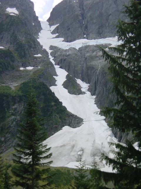
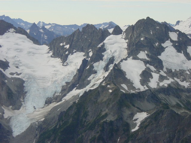
The 3400' couloir falling from the Cascade-Johannesberg col, with
the Sill glacier threatening the first two-thirds.

I was ready to go when Jens arrived at 11:00 PM. Remarkably, I've come to enjoy our all-night
blitzes. From my house we head to Kinkos to make copies of the route descriptions. The only machine that
has legal size paper also has a good bit of attitude. I emerge victorious after a tug-o-war over a
jammed piece of paper, and at 11:15 we head for the freeway. Two hours later we cross the bridge
in Marblemount and start up the Cascade River road, a 23 mile road to essentially nowhere, unless you are a logger or a climber.
Though clouds blanket the sky, the radiant full moon fills the valley with light. At twenty miles, near the parking lot for Forbidden, the massive north face of Johannesberg comes into view. We can see the hourglass shaped couloir glowing eerily in the night. It looks continuous, but its hard to tell for sure. Climbing steep, loose rock in the couloir would slow us down at the narrowest and most dangerous part of the route.
At the parking lot, ten minutes later, I open the door and a blast of cold air greets me. "It's pretty cool out, Jens. Not freezing or anything, but nice and cool."
"Yeah, that's good. Hopefully it will keep things stable in the couloir."
I pull all my gear out. Because of the questionable weather I packed gear for alpine and sport rock. Our plan was to go to Washington Pass or Leavenworth if the weather looked poor. We pack up, silently and efficiently. At 2:13 AM we each chug a Red Bull and leave the lot.
Johannesberg is blessed with one of the shortest approaches in the Cascades. In early season the snow
starts just a few yards from the road. But this is September, so we are treated to an approach
more characteristic to the Enigma Range, albeit short.
We leave the road and scramble down the steep slope to the creek. Though the crossing is easy, I am careful, since soaked feet would jeopardize the climb. From there we could see the base of the route, a huge avalanche fan that forms a permanent snowfield at 3300 feet. But between us and it was a bit of brush. Jens led into the schwack in the darkness. Though short and not severe by Cascades standards, it was unpleasant, particularly because I couldn't see my feet for most of it. Twice I slip and slide down on wet plants, arresting with my axe. The brush seemingly grows out of a talus field, not dirt, so the substrate is treacherous.
After almost 50 minutes of slipping, tripping, sliding, and scrumbling, we arrive at the base of the fan. The snow is firm, but not icy, providing a perfect surface for cramponing. At the top of the fan we encounter an unexpected obstacle: A wall to wall crevasse. In the dark we both grunt up and over eight feet of overhanging alpine ice.

Jens on the wall of the first crevasse. For some cosmic reason,
the pictures from this trip feature Jens' closed eyes rather than my finger.
Following our agreed plan, we try to stay near one side of the couloir or the other. We both look up frequently to scan for falling objects, and continuously ponder
the best place to run in the event that the mountain tries to swat us off.
A few hundred feet above the crevasse my headlamp fades to black. Though I have another set of batteries, I want to save them in case we descend in the dark or have to bivy. Between the moonlight and Jens' headlamp I can see well enough on the 30-35 degree slope.
Gradually the gradient increases and the couloir necks down. Below the narrowest point we stop in relative safety below a buttress. I change the batteries in my headlamp and we eat and drink a bit. Above us there is no place to get out of the bowling alley, though we will soon be safe from the threatening Sill glacier. Still ropeless, we leave the safe, flat sanctuary and climb into the bottleneck. For about 300 vertical feet the couloir is no wider that
fifty feet and as narrow as twenty feet. The slope increases to 40 degrees. I know that if something does come down on us there is no place to hide. Luck and an early start are our only allies.
We move up at our fastest sustainable pace. Another crevasse is passed on the left via short, steep ramp. I opt for two tools, while Jens uses just one. Soon the slope broadens and we are able to move to the left again.

Jens just above the crevasse in the bottleneck.
To our right we can see the Sill glacier glowing in the dark. Another crevasse forces us into the center of the couloir, the only place where it is still bridged by snow.
One hundred yards later we pass yet another on the far right. I look up and can see what appears to be the top of the couloir, though I'm not sure because I incorrectly set my altimeter in the parking lot. The angle has now steepened to 50 degrees, and we are perched on the slope with 3000 feet of exposure. Hugging the right
side we come to another wall-to-wall crevasse.
Though not wide, the uphill side is six feet above and vertical. I walk along the knife-edge lower lip to the easiest crossing point. Just a hundred yards above I can see the top of the couloir. I pull out my second tool and swing into the crevasse wall. Thunk. It is
water ice, not frozen snow. Thunk-thunk. I plant the other tool and kick my frontpoints into the wall. Two moves and I can swing over the top. It is a solid sheet of ice. "Shit, Jens. This is water ice."
"How far?"
I scan the steep slope above. "Looks like 45 feet or so."
I contemplate the terrain and the consequence of a slip. By ice climbing standards it is easy, AI2 at most. But I felt a little mentally frazzled from the continuous exposure. "I think we should belay this section."
I downclimb and place a screw in the blue ice of the crevasse wall while Jens flakes out the rope. We tie in and start our usual conversation about who is going to lead. Since his end of the rope is flaked on top, he leads out. Water runs down the ice and gushes into the crevasse. I
can't hear anything he was says because of it. He climbs past the ice and places a picket, then continues toward the col. When the rope runs out I holler up, pull the screw and we simul-climb. We reach the col at 5:30 AM, in pre-dawn light.
In our best-case plan we hoped to be at the col at 6:00 AM. Being early meant we could take a good break before heading out onto the rock section. I empty my pack, a new LaFuma Extreme Light 32, and put on most of my clothes. It isn't too cold, but I am wet from perspiration and a light breeze chills me. We sort out what gear we need to take above, choosing to leave the pickets, screws, a tool each, and some water. A moderate snow slope guarding the entry gully obliges us to take crampons and one tool.
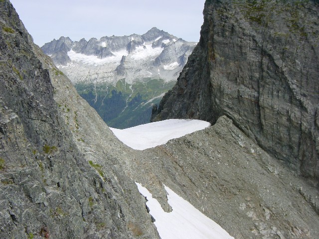
Cascade-Johannesberg col from the south side. We traversed the
snow slope at the bottom of the picture.
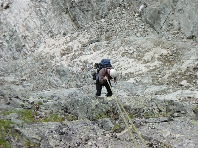
At 6:15 we rise and leave the col. The snow is softer on the south facing slope, and we cross its 200 feet with little problem. The snow is severely undercut at the rock, so we carefully choose a place to cross and tread lightly. On the rock we stow our axes and crampons, but opt to stay in our boots rather than putting on our rock shoes. Above us, the gully looks loose but moderate so we leave the rope packed up.
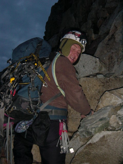
Jens starts up the first gully. Maybe he was just tired?
We start up the odd, white, concrete-looking rock. I find it steep but moderate. I'm careful due to the exposure, which I never seem to get used to. Loose rocks litter the steps, but what looks good generally is. After 150 vertical feet the gully ends at heather and blueberry benches. I start to bonk as we scramble up, but Jens is too, so we don't notice so much.
The route description says to aim for what looks like the highest point, so we know we can't see the summit. Above the benches we enter another gully. An occasional rap sling, some of frightening quality, leads us to believe that we are on the right track. The higher we get the worse the rock gets. In places the exposure is significant. A fall would result in a lot of impacts and bouncing. I start to contemplate the descent and decide to save that worry for later.
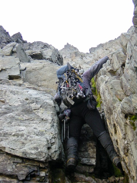
Jens working a short chimney mid-way up the gully system.
As we approach the crest of the ridge I expect that the route will turn left, which I thought was west, toward the summit. But 100 yards below the crest we turn right and ascend a final, dirty gully to the knife-edge ridge. I turn to my left, expecting to see the summit far off along the ridge, but instead see the snow and meadows on the south side of the col. We turn right and start traversing the ridge crest.
"Jens, I thought the summit was the other way, to the west?!"
"It is to the west, which is this way."
I decide that I need some calories and eat half a bar. Ahead of me Jens, a 5.12 climber, moves easily over the 3rd and 4th class terrain. He patiently waits as I move confidently, but decidedly more slowly. By now I can see the summit. It is behind two intervening towers. Without any size reference I can't tell if it is one hour or four hours away. I just keep moving over the crest, at times with several thousand feet of air below me. We pass the infamous "two-person bivy". Its level of improvement belies its frequency of use.
Just after the first tower we drop off the crest and onto a faint trail. An occasional
cairn beckons us onward. The terrain eases and becomes 2nd class. I'm relieved to have respite from the exposure and loose handholds. We near the last tower between us and the summit, and I still can't judge the distance. We round it and come to a deep, steep-walled slot. I glance up as we look for a way around and can finally see that the summit is just minutes above. Near the ridge crest we find a crossing and scramble onto the summit pyramid. After a few more loose handholds we walk onto the summit. It is 8:25 AM.

Jens at the head of the slot, and the base of the summit pyramid.
The summit is also adorned with a well-used bivy spot. We sit, relax, and read through the entries in the summit log. There, from 1995, is Jens' entry after his climb of the Northeast Face. Five people have signed in 2001. From earlier years there are entries from someone who soloed the Northeast Buttress and a party who made it from car to summit in 4:45. 4600 feet below (but only one mile away) I can see Jens' car in the parking lot.

So close, and yet so far: Cars in the parking lot, 4600 vertical
feet and one horizontal mile away.

On the summit at 8:30 AM. Coincidentally, our friends reached the
summit of Eldorado, which is adjacent to my left knee, at the same time.
Mount Formidable (right) and the Middle Cascade Glacier (left).
Time plays tricks on me when I climb. Fifteen minutes at a cold belay can seem like an hour. And 30 minutes on a summit always feels like five. And so it was as we left the summit 9:05 AM, after forty real minutes, but just ten
'Loren' minutes.
Returning to the col was as tedious as I feared. We followed the faint climber's track and cairns past the point where we'd found it on the ascent, finally regaining the ridge when it ended in steep gullies. In the gullies I was slow and tentative, mistrusting every rock after a recent close-call on Mt. Garfield. Though Jens could've easily downclimbed it all, we ended up making three raps on a 60 meter rope, mostly to save time because of my slow downclimbing.

Jens waits patiently. Spider Mountain is above him and the Middle
Cascade glacier is to his left. And yes, if you look closely, his eyes are
closed.
Jens rapping down a gully.
It seems to me that there are two keys points on the descent: Choosing the correct place to leave the ridge crest and choosing correctly from no less than five similar looking gullies below the heather benches. I don't remember anything noteworthy about where we left the ridge. The initial descent is via an indistinct dirt gully. A rap sling currently marks the correct gully below the heather. Though a single rap into that gully didn't reach the snow, it got us to a point where I felt comfortable downclimbing.

Looking down from the heather and blueberry benches. The correct
descent gully is the one on the left.
At the snow we put our crampons on and take out our axes to cross the short snowfield.
"I may be singing a different tune in an hour, Jens, but right now I am glad to be done with the loose rock."
At 11:26 we sat back down at the col. 2.5 hours to the summit from there, 2.5 hours back. We ate and drank while we repacking our gear and scheming about the descent. "Whoever goes first should put in a picket so we have some protection while downclimbing the crevasse below the ice."
"Agreed."
Somehow I ended up going first. I feel bad about it now, as it was the easier assignment. Jens volunteered a belay from the moat where the snow on the col ended. I agreed, then thought again.
"Look, you might as well lower me. It'll be faster than reverse front-pointing. I don't much care about style up here, I want to get down this thing as quickly as possible."
About fifty feet down the face I stop and pound in a picket. One hundred feet later I hear a muffled holler and guess that the rope is out. I place a screw in the ice and holler back for him to start down. I'm having a hard time seeing the spot where we crossed the crevasse on the way up. Then I realize it is far to my left. I'll have to traverse the slope another fifty feet to reach it. I look back at the screw twenty feet to my right and at the same level. I've screwed
myself (bad pun unintended). The rope is now protecting Jens, but not me. I suck it up and start traversing. Contrary to the screw, the picket is placed perfectly: Jens is ten feet above it as I reach the upper lip of the crevasse. So if I fall on the steep downclimb I'll only pendulum into the slot, and Jens will only fall a few feet, if at all.
I yell to Jens that I am starting "the business" and climb down the upper wall of the crevasse. Though the ice has softened, I find an area of blue ice, chop off the soft stuff, and place a good screw. I yell up to Jens that he is on belay and he starts down. Unfortunately, he has to repeat my route in order to clean the screw, but he still makes short work of the whole thing. He continues down from the crevasse, reverse front-pointing, while I belay. With the rope close to running out, he places a picket. Then I clean the screw and start down, too.
Now there was 180 feet of rope between me and the picket. I consider that a fall would be long, unless I didn't make it over the crevasse that Jens was making his way around 195 feet below me.
After what seems like an hour I reach the picket. Jens is now on more moderate terrain and is carefully walking face-out.
I chastise myself for being the slow one again. I start to hurry, then stop when I realize that a fall would slow us more than anything, especially since there was no pro between us. Axe in, step-step. Axe in, step-step. I traverse around the crevasse and past it. Finally I turn around and started a descending traverse of the slope.

The upper section of the couloir. The bluish, glistening area
just below the top is the ice.
The snow has softened. I can feel that the points of my crampons are just making it into the firmer layer below the mush. Though it is soft enough to arrest, I know I would get just one chance before I accelerating out of control. I contemplate untying and having Jens collect the rope, but I decide that speed is of the essence and just continue down. The lower we go, the greater the chance of being hit by rock or ice. Five-hundred vertical feet below the col we find a spot to tuck in under a crevasse, out of the firing line. We rest and drink, then untie and coil the rope.
The angle of the slope eases as we continue down. I still traverse back and forth, but I am taking a steeper line down. Near the middle of the bottleneck I pull out my second tool and downclimb a steep ramp through a crevasse. Another five hundred feet and the slope gets wider. We are able to hug the right wall and get out of the fall line. The slope eases back to 30 degrees as we approach the last obstacle, the unexpected crevasse at the top of the avalanche fan. I go first, standing on a small ledge deciding whether to jump or downclimb. Jens points out that the snow is soft, but the landing is flat and rock-strewn. I downclimb the overhanging lip, then hand up a tool to Jens (he has one technical tool and a walking axe). He looks over the edge and jumps, rather than downclimbing. We have a good laugh about that as we angle right down the fan. I feel relieved to be though with the exposure and safe from rock-fall and avalanche.
We take the shortest line off the fan, stopping at the moraine to take off our crampons. On the way down we scope out a better route, avoiding most of the brush. We cross the creek just below the dirt slope that leads to the road. Five minutes later, at 3:20 PM, we arrive at the car.
Cold beers appear from the cooler. Dry underwear and clean cotton clothes are donned. We stop at the Forbidden parking lot on the way out to snap a few pictures. There is only one car at the Eldorado lot. Though it looked familiar at the time, it was only later that I found out it belonged to a friend.

The couloir. Our route in blue. The water ice section circled..
A Red Bull and a Coke kept Jens mostly awake on the drive to Sedro Wooly. We ate heartily at a Mexican place. At 7:30 we pulled into my driveway.
Thoughts:
