Coleman Glacier Headwall
July 30-31, 2000

The North Face of Mt. Baker with the base of the Coleman Glacier
Headwall at the arrow. This image was taken in July of 2001 after an ascent of
the North Ridge, the left skyline. Note that the Headwall appeared to be in better
shape in 2001 than during our climb in 2000.

In typical form, Jens and I had decided to do something, but we waited until
the last minute to decide on what. After a series of manageable one-day climbs
we were both itching for something a bit harder. We initially planned for two or
three days, and Ptarmigan Ridge was the frontrunner on my list. But when our
trip shrank to a day and a half, we decided on the Coleman Glacier Headwall.
On my first ascent of Mount Baker, on the Coleman-Deming route, in 1996, I
spent several hours after returning from the summit watching two climbers on the
Headwall. It looked steep, long, and hard. I wondered then if I'd ever have the
skills to climb routes like that. So I was excited when we chose it for our
weekend fun.
After some debate we opted against a car-to-car push and departed Issaquah at
1:30 PM on a sunny Sunday. After a quick stop at the Taco Bell drive-through in
Bellingham and one more at a grocery store for some post-climb beer, we left the
trailhead at 4:30 PM. After a near-dunking while stashing a couple beers in the
creek 100 feet down the trail, we were truly under way at 4:45 PM.

Evidence of a late start: Our shadows on the approach.
We made good time up the well maintained Heliotrope ridge trail. By 6:15 we
were switching to plastic boots at the top of the moraine. At 7:00 we were
improving a nice bivy spot on the ridge just above the snow camps at the Black
Buttes.
While we brewed up and ate we took turns scoping out the route with the
binoculars. From our vantage there appeared to be three cruxes to the route: A
large crevasse about 2/3 up the face, a large blue-ice cliff near the beginning,
and last, but not least, getting across the lower Coleman to the base of the
headwall. On the way in a pair of North Ridge climbers had provided the
following tip: "We climbed too high on the Coleman, about 8500'. We had to
drop all the way down to 7000' to get across. Go low."

Sunset over the San Juans from our bivy.
So we tried to spy out a line that would put us at the base of the
Roman Nose with any excessive elevation gain and loss. A large boulder loomed
out in the middle of the Coleman. We finally agreed that we could probably make
it to that boulder on a rising traverse and from there it would be a short walk
to the Headwall, proper. That issue resolved, we turned our attention to the
imposing headwall. The first obvious obstacle was the blue-ice cliff near the
base. We decided this could be passed either by directly climbing the middle in
a single ice pitch, or by working up the far left through a jumble of ice
blocks. Above the cliff was a small snowfield that led to a series of
crevasses. The last of this bunch completely bisected the Headwall, save for a
small weakness on climber's right. Above that was a large, steep snowfield that
appeared (from our location) to have glissade tracks in it. That snowfield ended
in a diagonal crevasse that ran from the ice cliff of the summit ice cap on the
left to a rock band about 700' lower on the right. This looked like it would
turn on the right, near the rocks. Once past that crevasse, we would be free of
most objective danger and separated from the broad summit plateau only by a
final snowfield.
Now that we had the puzzle of the route solved (uh, huh), we turned our
attention to the task at hand: Dinner. One two-serving bag of AlpenAire Mountain
Chili each. Yum.
By 9:30 we were trying to sleep. Unfortunately, there were three things
conspiring to minimize my sleep that night:
- I was nervous about the route.
- We both snored like chainsaws and kept waking each other up.
- The combination of a Taco Bell lunch and a Mountain Chili dinner.
Yes, folks, at about 10:30 PM my body began ejecting the most foul,
voluminous, and incessant gas I have ever experienced. Like the snoring, it was
affecting us both. Amidst nerves, snoring, odiferous emanations, and a
super-hydrated bladder, I'd slept about two hours when the alarm went off at
1:30 AM.
I looked at my trusty Suunto Vector: 54 degrees. Not exactly the perfect
temperature for traversing a crevasse-riddled glacier to climb a 2000' headwall.
But we drank some water, ate a bar, roped up, and took off across the Coleman
toward our boulder at 2:30 AM. I'll cut to the chase: There was only one way
across the Coleman that did not involve climbing overhanging seracs and/or
Tyrolean traverses: To climb to 8000' (where we met the tracks of the North
Ridge pair), and then descend 350' to cross under the Roman Nose. And even this
involved a questionably reversible downhill crevasse jump and negotiating a four-foot
vertical step.
At 4:45 AM we reached the base of the Headwall and took a good rest while we
evaluated the route once again. After misreading the traverse of the Lower
Coleman, we wanted to get the Headwall right.
I took the first lead and headed up the snow/debris field to the right. We
simul-climbed into the icefall below the imposing blue ice cliff. Just below the
cliff we swung leads and Jens went up to the cliff. The center, while the
shortest route (about 20 feet), was vertical to overhanging. That, combined with
the balmy temperature, led us to scout the icefall to the far left of the cliff.
Though less steep, it was rotten water ice. As Jens climbed up I set both tools
for a belay. True to form, Jens cleared the "Monkey Business", using
two screws for protection. I followed with the security of a top rope.

Jens leading the first ice pitch.
Above the
cliff I led out on a 60 degree snow slope. It had a nasty breakable crust that
made it strenuous and stressful. At the lip of a filled crevasse I pounded in a
picket. Jens pulled the belay and we simul-climbed again. The slope eased back to
45-50 degrees and far above I could see
the rock band that marked the final crevasse. I led up into the next crevassed
section. For some reason I opted against an obvious central gully and traversed
left and up to another ice cliff. Underneath the cliff I traversed back right to
the top of the gully. The obvious gully ended in a nasty crevasse that was
hidden from below. Sometimes it pays to listen to that little voice.
Of course, there was also a large crevasse directly in front of me. I was
forced to traverse back left for about 75 feet, gaining about 30 vertical feet,
then back down a slender finger to get around the mess. I walked 150 and ended
up 12 feet from Jens, who was protecting me with a boot-axe belay.

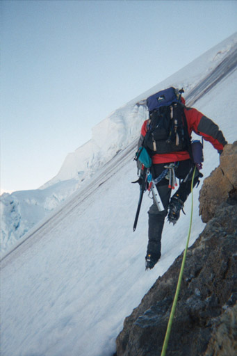
Jens with a boot-axe belay while I traverse up and then down.
I climbed up
another 20 feet, buried both axes and belayed Jens around the crevasses
and on up. I was glad to have some nice steps to follow through the next
snowfield.
By now it was about 7:30 AM. And we were both still suffering from the Taco
Bell/ Mountain Chili after-effects. Farting in Goretex is repulsive. With pants
and a jacket on, there is only one place for all that warm air to escape: The
neck.
Jens led up the snowfield to the next crevasse. This was the largest and
final one in the grouping. It appeared to have only one weakness. Jens turned it
on a very tenuous snow bridge. He put in picket above it and we climbed on. I
got another boot-axe belay as I gingerly crossed the fragile looking bridge. Now
only one more crevasse lay between us and the final snowfield. Jens continued in
the lead up the 50 degree slope. Here we learned that the tracks we'd seen from
camp were glissade tracks, but from boulders, not humans. The rock band above
was 5.trundle and was clearly making itself smaller on a regular basis. The
bright side is that the slide tracks made for good cramponing.
Jens protected the vertical moves across the last crevasse with an ice screw.
I passed it and were we finally free from the threat of rock and ice fall. 100
feet above Jens found an acceptable spot in the rocks to sit. He put in a couple
nuts and belayed me up. We took our first real mental and physical break in four
hours.
From the rocks it looked to about 200 vertical feet to the ice cap. I led out
and up the crusty, steep slope.
Me leading out from the rocks. Note the black ice above my right shoulder.
I was still using two tools, shafting them to
their heads in the soft snow. The slope started to lay back, but the crust was
unrelenting. The 200 vertical was actually more like 500. Jens offered to give
me a break, but I was determined to take us home.

Finally breaking in to the sunshine. 9:45 AM, July 31.
At 10:00 AM we reached the
southeast corner of the summit plateau and climbed the final 50 foot slope to
the summit. There we met three very nice folks from Monroe who took our picture.
Then we sat in the mud and got our gear all dirty.

On the summit, with the tip of Sherman Crater on the left.
After a brief respite on the summit, we headed down the standard
Coleman-Deming route. We were able to glissade most of the Roman Wall, until the
route traversed onto the rocky and dirty ridge. We roped back up at the 9000'
col and made fast time back to our little bivy spot. We packed up and charged
down the glacier, making a fast, fun roped glissade back to the top of the
moraine. We made brief stop to retrieve our cold beer from the creek and were
back at the car at 2:15 PM.
At the car we drank our beer and watched a guy
load more ice screws than I've ever seen in one place (even in a store) into his
pack for "some seracing and the North Ridge."
I hope he was able to
find some harder snow down low than we did.

Cold beer at the car. And Jens thought he looked bad!
What a fun, challenging glacier climb. Between this and finally
getting a winter ascent of Rainier in March, my two favorite volcano climbs have
been in the year 2000.